Enhancing the Quality of Height and Pressure Measurements in Radiosoundings
This article presents improved ways of working in synoptic sounding, which is used to acquire atmosphere profiles. The key points are gathered from the field and supported by recent research.
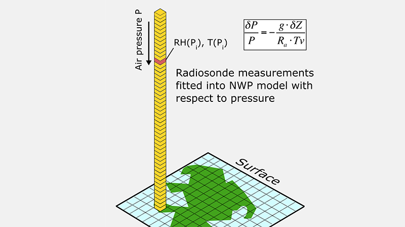
In radiosondes utilizing a pressure sensor, atmospheric pressure is measured directly by the radiosonde. The measured pressure is then used together with atmospheric humidity and temperature profiles, as well as surface pressure to calculate geopotential height [1]. The current trend for National Meteorological Services (NMS) is to use radiosondes with GPS based pressure measurement. These radiosondes calculate the atmospheric pressure using the GPS height difference of the radiosonde and the ground station together with the measured humidity and temperature profiles and ground station pressure using the hypsometric equation shown in figure 1 [2]. Visualization of the GPS based pressure measurement including the use of the hypsometric equation can be found in [3] and [4].

Figure 1: Schematic showing how sounding parameters such as relative humidity (RH) and temperature (T) are associated to standard pressure levels. The pressure can be calculated using the hypsometric equation in the top right corner, where P is pressure, g the gravity constant, ?? the change in geopotential height, ?? the gas constant for dry atmosphere and ?? the virtual temperature.
As illustrated in the figure above, humidity and temperature profiles are assimilated to Numerical Weather Prediction (NWP) models with respect to pressure levels, not altitudes. For this reason, errors in radiosonde height data have not received much attention in recent years [5]. After all, errors in station altitude and offset corrections do not translate to pressure errors in radiosondes with onboard pressure sensors. The current generation of radiosondes without pressure sensors, however, are affected by errors in station altitude and offset corrections. Because radiosondes without a pressure sensor calculate the pressure from measured height, errors in the station altitude or offset corrections will cause an error to all of the radiosonde pressure levels. In the lowest kilometers of the atmosphere an error of a few meters in height will lead to several tenths of hPa error in pressure. Although the error decreases significantly during the ascent, all pressure errors will cause temperature and humidity values to be associated to incorrect pressure levels. This can produce errors in numerical and climate models that are larger than the actual measurement uncertainty of the temperature or humidity sensor in the radiosonde. [6]
Recent research [5] has identified several easily implemented improvements to sounding station height parameters that can lead to clear improvements in data quality. A common error is incorrectly specified station altitude, which can result from typing errors, failure to update new station altitude after relocation or even incorrect station altitude information from WMO [7]. As GPS antennas are common at sounding stations, it may be tempting to use the direct GPS altitude as the station altitude. Unfortunately, the absolute accuracy of the GPS altitude is poor due to slowly changing atmospheric and ionospheric conditions which affect data transmission. If there are no alternatives to GPS altitude, great care should be taken to use the correct GPS reference system. The default height given by GPS systems is relative to a reference ellipsoid, whereas heights relative to the Mean Sea Level (MSL) are required for meteorological purposes [5]. The difference between the two altitude readings can be up to 100 m [5]. Because of the reasons listed above, it is important to assess the station level altitude by surveying or using other similar methods. The measured station altitude should then be communicated to WMO to ensure the altitude is updated to data centers responsible for NWP.
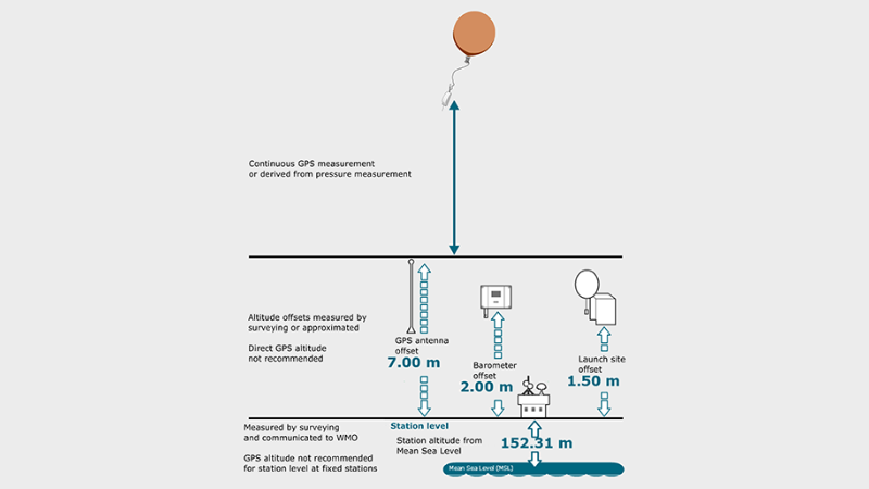
Another potential source of error arises from the height offsets of the GPS antenna, barometer and launch site. The barometer reading at the sounding station calibrates all observations of the pressure profile for radiosondes with GPS derived pressure measurement. Therefore, it is crucial to assign a correct altitude offset value to the barometer and to use a properly calibrated reference pressure sensor. In addition to the barometer, the GPS antenna offset should be assessed relative to the station level. Although it may be tempting to simply deduct the station altitude from the direct GPS reading, it is not recommended due to the previously stated reasons related to GPS accuracy. [3]
The launch site offset is used to indicate a significant difference between the launch site altitude and station altitude. The offset is used to determine the launch site pressure and geopotential height and readjust the launch site altitude in TEMP and BUFR messages.

Figure 2: Recommended methods for assessing station level and offset corrections for the GPS antenna, barometer and launch site. Utilizing direct GPS altitude for station altitude or offset assessment is not recommended.
The station altitude, different offset corrections and recommendations for height and offset assessment can be seen in figure 2. A similar screen is shown in the station configuration page of the Vaisala Sounding System MW41 Software, which can be found in Administration → Sounding → Station.
After correct ground station configuration, additional height accuracy can be achieved by using native high-resolution BUFR coding of the sounding message, which is generated by the sounding system. Because TEMP messages are in such compact form, altitudes of significant levels at 500 hPa and higher are rounded to the closest 10 meters. To meet WMO recommendation of moving to BUFR messages, some NMSs are converting TEMP messages to BUFR. However, in some cases, the conversion results in messages that do not meet the BUFR specifications and are rejected by the NWP centers [5, 8]. To get full accuracy of the sounding system, the message format conversion is not sufficient. The use of native, sounding system generated BUFR is required to avoid the 10 m rounding error inherent to TEMP messages. [5]
As shown in this article, careful height settings in the ground station, as well as the generation of high resolution BUFR messages directly from the sounding system are necessary to gain the full meteorological value from the sounding operations.
If you have any questions or comments related to this application note or soundings in general, please contact your Vaisala representative.
REFERENCES
[1] H. Richner and P. Viatte, “The Hydrostatic Equation in the Evaluation Algorithm for Radiosonde Data,” Journal of Atmospheric and Oceanic Technology, vol. 12, pp. 649–656, 1995.
[2] R. M. Stauffer, G. A. Morris, A. M. Thompson, E. Joseph, G. J. R. Coetzee, and N. R. Nalli, “Propagation of radiosonde pressure sensor errors to ozonesonde measurements,” Atmospheric Measurement Techniques, vol. 7, no. 1, pp. 65–79, 2014.
[3] Vaisala, “GPS-Based Measurement of Height and Pressure with Vaisala Radiosonde RS41” [Online].
[4] R. Lehtinen, P. Survo, and H. Jauhiainen, “Comparison of Two Radiosonde Pressure Measurements: Pressure Sensor vs. GPS-Derived Pressure,” in 18th Symposium on Meteorological Observation and Instrumentation, 2016, pp. 1–9.
[5] B. Ingleby, M. Dahoui, and M. Lehmuskero, “Improved radiosonde height reports : reporting precision , GPS reference height and other issues,” 2016 [Online]. Available: TECO 2016.
[6] Vaisala, “Accuracy Matters in Radiosonde Measurements” [Online].
[7] B. Ingleby, “Assimilation of Station Level Pressure and Errors in Station Height,” Weather and Forecasting., vol. 10, pp. 172–182, 1995.
[8] B. Ingleby, P. Pauley, A. Kats, J. Ator, D. Keyser, A. Doerenbecher, E. Fucile, J. Hasegawa, E. Toyoda, T. Kleinert, W. Qu, J. St James, W. Tennant, and R. Weedon, “Progress towards high-resolution, real-time radiosonde reports,” Bulletin of the American Meteorological Society, p. BAMS-D-15-00169.1, 2016 [Online]. Available: http://journals.ametsoc.org/doi/10.1175/BAMS-D-15-00169.1

Comment
Add new comment